If you've already toured Birchwood Way you'll know that Warrington New Town had plans for a network of expressways that never happened, save for the half-built Birchwood Way itself. This page looks at the plans for the whole of Warrington to put Birchwood into perspective.
Overview
Warrington New Town Development Corporation had a more complex task than the bodies responsible for other New Towns as it had to create its modernist utopia around an existing industrial settlement in South Lancashire. The existing built-up area was in the centre of its development, so anything new had to be built around the outside. As a result the Corporation designated four districts around the edge which formed the new town development and which were allowed some autonomy in their planning. The existing area formed a fifth district.

All of this meant that the overall plan was flexible and allowed a good deal of agency to the five districts, calling only for the designation of residential and industrial areas and the layout of main transport corridors. The outline plan for the transport network is shown above.
A book about New Towns, written as Warrington was beginning construction work, provides some background information about what its planners were attempting:
"In the plan the designated area is divided into 5 main districts, each with a target population in 1991 indicated in brackets, the central district (71,500) approximately the area of the former county borough, two districts in the eastern extension, Padgate (26,500 since amended to 33,200) between the old town and the M6, and Birchwood (21,000 since amended to 18,000) to the north-east beyond the M6, Westbrook (44,500) occupying the western extension, and Bridgewater (38,000) south of the Manchester Ship Canal."
In terms of its road network, the outline plan was very simple, providing two east-west expressways and one north-south one. These roads were to be grade-separated dual carriageways, and formed the upper tier of a hierarchy of roads. 'Distributors' were the only roads to interchange with the expressways and provided the main routes passing through the built-up areas themselves.
The expressways provided for nearly all motorway access in the New Town area, with the northern one joining M62 J11 with the proposed J8 (the existing J8 was built much further east than originally planned). The central expressway ran west from M6 J21 through the town centre, and had scope for a continuation to Widnes. The north-south route joined the northern expressway straight to M56 J10. The main surprise is that there was no expressway designed to link to Runcorn's very similar network just a few miles to the south west.
A much larger version of the plan is below; notice, however, that it dictates very little to the five districts. It also circles certain areas for joint consultation with neighbouring authorities.

Town centre
The central area of Warrington was originally to be redeveloped to form a suitable core for an enlarged town. The rezoning of the town centre was designed to cause as little disruption to existing uses as possible; the new transport network, however, was a different question.
A single-carriageway inner ring was to circle the commercial district, within which all streets would be pedestrianised. However, this route was not designed to take large amounts of traffic, and was aided a short way further out by the central east-west expressway bordering the northern edge of the centre, following the railway viaduct; a new dual-carriageway bypass to the east; and a set of new complex interchanges to help the sole crossing of the River Mersey at Bridge Foot to function more efficiently.

Birchwood
Outside the town centre, each district was to have one or more smaller district centres. Birchwood's was by far the largest, however, designed to serve the needs of the population who were furthest from Warrington town centre.
Again, our contemporary source looks at what was planned for Warrington's districts:
The centre is planned mainly as a pedestrian precinct encircled by a local distributor road with two branch accesses, and footpath access from the principal directions and from the railway station to the south. The shopping facilities, including a departmental store and supermarket, are grouped round pedestrian areas, while a library, health centre, youth and community meeting rooms and old people's day centre are grouped round a pedestrian square. In the south-east of the centre is a secondary school with with part planned for community use, while in the northern section of the centre an area is devoted to housing... A narrow green belt surrounds the centre on three sides. If built as planned it should be a good district centre with easy access serving well the needs of the community.

As for road access, Birchwood was bisected by the northern east-west expressway (visible across the top of the district centre plan, above, with a different junction layout to that eventually built). It was never built as planned, however, leaving the A574 Birchwood Way a half-built nod to what was intended. The diagram below allows a comparison with the original plans.
What was built
Warrington New Town Development Corporation never got to finish its job. The Government of the 1970s reduced its target population by about 30,000, meaning that plans for Westbrook were redrawn with more open space and less housing, and the less advanced proposals for Bridgewater were drastically cut back. In the 1980s Margaret Thatcher's Government, viewing the New Towns as a failed social experiment, dismantled the Development Corporations up and down the country, returning Warrington first to Cheshire County Council and then to Warrington Borough Council when it became a unitary authority.
Expressways
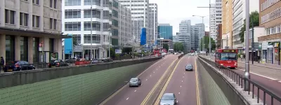
The grand plans for expressways were stopped before they could even begin, as no work had been carried out before the population target was lowered. Birchwood Way in its current state was mostly built in the early 1980s; ten years earlier and it might have been finished.

The only other clues to the plans are in some copycat road alignments - an unclassified road built to link a young offender's institute south of Warrington to the M6 during the 1990s, for example, seems to have its alignment lifted straight from the plans for a 'distributor' linking the north-south expressway to M6 J20. Aside from that, a few lingering street names give the game away. Knowing that the northern expressway was named Birchwood Way as it passed through Birchwood helps identify Sankey Way, a brief dual carriageway in Sankey, and Westbrook Way, a minor road with incredible amounts of space on either side in Westbrook. There's also about 50 metres of the A57 east of Warrington Town Centre which the A-Z map thinks is named 'Southern Expressway'.
Westbrook is the most changed of all the areas - its redrawing changed its arterial route from the northern expressway to Cromwell Avenue, a single-carriageway horseshoe that stops for a roundabout approximately every three metres. M62 J8 was finally built to access Ikea at Westbrook, which was certainly not in the original plans!
Town Centre
The town centre itself was three-quarters redeveloped and then abandoned: its single-carriageway inner ring was three-quarters built and then halted. The area within it is pedestrianised but its north-western quarter was removed in late 2005 and is now replaced by a large shopping mall. It was only then that the bus station was moved to its intended home next to Central station.
Further out, it took until the 1990s for Warrington's other roads to be built - a second bridge over the Mersey instead of a system of flyovers solved the problems at Bridge Foot; a dual carriageway bang on the line of the eastern bypass; and even a new elevated route alongside the railway viaduct, remarkably similar to the central expressway plan, though it is only a single-carriageway.
Birchwood
Osborn and Whittick claimed that if Birchwood district centre was built as planned it would serve the area well. Unfortunately it wasn't built as planned - instead the housing was pushed further out in favour of swathes of school playing fields, and the nature reserve gave way to enormous business parks. The 'precinct' became Birchwood Mall, where the indoor shopping environment sucked the life out of the outdoor shopping arcades. Today the district centre is a glossy American style Mall surrounded by surface car parks and a barren wasteland of faceless office blocks, abandoned shops and muddy playing fields. The police have moved out; the community facilities have closed; the entertainment centre is now a call centre; the library is now within the high school.
Conclusion
It's clear that Warrington New Town turned out differently to how it was originally envisioned, principally because the goalposts were moved so often that it was impossible to keep the simplicity of the outline plan in place.
However, we should be careful not to judge the New Town as a failure on the grounds that it wasn't finished as it was intended, simply because it is impossible to tell whether it would have worked any better if the masterplan had been seen through to the end. Nevertheless, the confused mix of authorities that have developed the town through the twentieth century might well have benefitted from a more coherent long-term strategy.
Picture credits
- Diagrams of Warrington, the town centre and Birchwood were extracted from "Warrington New Town: Outline Plan" by Warrington New Town Development Corporation.